Weas-El-Bot (talk | contribs) m (r2.7.10) (Bot: Adding ru:Тёмные Земли) Tag: apiedit |
Weas-El-Bot (talk | contribs) m (Bot: Adding es:Tierras Oscuras) |
||
| (29 intermediate revisions by 14 users not shown) | |||
| Line 1: | Line 1: | ||
| + | [[File:Arda001.gif|thumb|Tolkien's original map of the Dark Land in relation to the rest of [[Arda]] during the First Age]] |
||
| − | :<font color="#990066">''(See also [[Mordor]], the dwelling place of Sauron in the southeast of Middle-earth. Mordor literally means "Dark Land".)''</font> |
||
| + | :''See also [[Mordor]], the dwelling place of Sauron which bears a name that means "Dark Land"'' |
||
| − | The '''Dark Land,''' or '''South Land,''' was a mysterious continent south of [[Middle-earth]] and east of the [[East Sea]]. |
||
| + | The '''Dark Land''', also referred to as the '''South Land''', was a continent that lay southeast of where the events of the ''[[The Silmarillion]]'' and ''[[The Lord of the Rings]]'' occurred. |
||
| − | ==History== |
||
| + | == History == |
||
| − | Not much is known about this continent, except that it formed during [[Morgoth]]'s [[Arda Marred|marring]] of the world by breaking away from the main part of Middle-earth (Endor). No [[Elves]] or [[Dwarves]] lived there, [[File:Arda001.gif|thumb|Tolkien's original map of Hyarmenor (the Dark Land) in relation to the rest of Middle-earth during the First Age.]] but it is possible that wild [[Men]] may have lived there at some point. The [[Númenóreans]] probably visited it on their long journeys, although it is not known if they established dwellings there. Most of the continent is covered by vast dense forests bordering much of its shorelines. |
||
| − | <ref>''[[The Atlas of Middle-earth]],'' The First Age, The Elder Days, "Introduction"</ref><ref>''[[The Atlas of Middle-earth]],'' The Second Age, "Introduction"</ref> |
||
| + | The Dark Land was created as a byproduct of the [[War for Sake of the Elves]], in which the [[Valar]] overthrew [[Melkor]] in his original fortress of [[Utumno]].<ref>''[[The History of Middle-earth]]'', Vol. IV: ''[[The Shaping of Middle-earth]]'', V: "[[The Ambarkanta (chapter)|The Ambarkanta]]", First Ballantine Books Edition</ref> Originally, [[Middle-earth]] was one landmass, set between the western sea of [[Belegaer]] and the [[East Sea]].<ref>''[[The History of Middle-earth]]'', Vol. IV: ''[[The Shaping of Middle-earth]]'', chapter V: "[[The Ambarkanta (chapter)|The Ambarkanta]]", Map IV</ref> This changed during the War, when the inland [[Sea of Ringol]], originally landlocked and set in the mid-south of Middle-earth, grew in size and "became a great sea flowing north-eastward and joining by straits both the Western and Eastern Seas."<ref>''[[The History of Middle-earth]]'', Vol. IV: ''The Shaping of Middle-earth,'' chapter V: "[[The Ambarkanta (chapter)|The Ambarkanta]]", First Ballantine Books Edition</ref> This event split Middle-earth into two landmasses; the landmass to the south and east of the former Sea of Ringil (which was also called the "East Sea" by Tolkien) was known as the Dark Land.<ref>''[[The History of Middle-earth]]'', Vol. IV: ''The Shaping of Middle-earth,'' chapter V: "[[The Ambarkanta (chapter)|The Ambarkanta]]", First Ballantine Books Edition, Map V</ref> |
||
| − | As seen in the ''[[Ambarkanta]]'', it occupies a position on [[Arda]] much like Antarctica and Australia do compared to Eurasia, if Antarctica and Australia were one land-mass.<ref>''[[The History of Middle-earth]]: [[The Shaping of Middle-earth]], "[[Ambarkanta|The Ambarkanta]]"''</ref> |
||
| + | No habitations in the Dark Land were ever recorded. The [[Númenóreans]] might have visited it on their long eastward journeys. If so, it is not known whether they established dwellings there. |
||
| − | In the game ''[[Middle Earth Role Play]]'' by [[Iron Crown Enterprises]], a [[Quenya]] name for the Dark Land—'''Mórenorë''' ("Dark Land")—was given, although it does not appear in any of Tolkien's writings; the name Hyarmenor, "south-land" is given instead in Tolkien's works (''The History of Middle-earth''). |
||
| + | == Portrayal in adaptations == |
||
| − | ==Behind the Scenes== |
||
| + | In ''[[The Atlas of Middle-earth]]'', [[Karen Wynn Fonstad]] interprets the continent as being covered by vast dense forests bordering much of its shorelines.<ref>''[[The Atlas of Middle-earth]],'' The First Age, The Elder Days, "Introduction"</ref><ref>''[[The Atlas of Middle-earth]]'', The Second Age, "Introduction"</ref> |
||
| − | Before Africa was visited by people from Europe, it was known as the "Dark Land". It is possible that [[J.R.R. Tolkien|Tolkien]] could have been inspired by this; also, he was born in South Africa. However, the continent directly south of [[Gondor]] where [[Harad]] was located (possibly corresponding with the Sahara Desert, as they are similar in position) is closer in shape to Africa, as well as being the proper distance away from Middle-earth (if Middle-earth is taken to be [[Europe]] and [[Rhûn]] is taken to be Asia). |
||
| + | In the game ''[[Middle Earth Role Play]]'' by [[Iron Crown Enterprises]], a [[Quenya]] name for the Dark Land, '''''Mórenorë '''''("Dark Land"), was given, although it does not appear in any of Tolkien's writings; the name '''''Hyarmenor''''', "south-land" is given instead in Tolkien's works (as seen in ''The History of Middle-earth''). |
||
| − | Some fans have speculated that this land may have become the southern portion of the [[New Lands]] at the end of the [[Second Age]] (the [[Land of the Sun]] being the northern portion). |
||
| + | == Behind the scenes == |
||
| − | {{Places}} |
||
| + | Before Africa was visited by people from Europe, it was known as the "Dark Land". It is possible that [[J.R.R. Tolkien|Tolkien]] was inspired by this; also, he was born in South Africa. However, the continent directly south of [[Gondor]] where [[Harad]] was located (possibly corresponding with the Sahara Desert, as they are similar in position) is closer in shape to Africa, as well as being the proper distance away from northwest [[Middle-earth]] (if northwest Middle-earth is taken to be [[Europe]] and [[Rhûn]] is taken to be Asia). |
||
| − | ==References== |
||
| − | <references/> |
||
| + | As seen in the ''[[Ambarkanta]]'', Dark Land occupies a position in [[Arda]] much like Antarctica and Australia do compared to Eurasia, if Antarctica and Australia were one landmass. |
||
| + | Some fans have speculated that this land may have become the southern portion of the [[New Lands]] at the end of the [[Second Age]] (the [[Land of the Sun]] being the northern portion). |
||
| + | ==Translations== |
||
| − | {{Space|Dark Land}} |
||
| + | <div style="overflow:auto; height:300px; width:500px; float:left"> |
||
| + | <!--<div style="overflow:auto; height:200px;">--> |
||
| + | {|class="itemtable" bgcolor=#EDEEFF style="color:#6f3d0b; border:2px solid #FFF; border-top: 0; text-align:left; -moz-border-radius-bottomleft:8px; -moz-border-radius-bottomright:8px; -webkit-border-bottom-left-radius:8px; -webkit-border-bottom-right-radius:8px;" |
||
| + | |width=300px|'''Foreign Language''' |
||
| + | |width=300px|'''Translated name''' |
||
| + | |- |
||
| + | |Afrikaans |
||
| + | |Donker land |
||
| + | |- |
||
| + | |Albanian |
||
| + | |Vendi i errët |
||
| + | |- |
||
| + | |Amharic |
||
| + | |ጥቁር አገር |
||
| + | |- |
||
| + | |Arabic |
||
| + | |بلد مظلم |
||
| + | |- |
||
| + | |Azerbaijani |
||
| + | |Qaranlıq diyar |
||
| + | |- |
||
| + | |Basque |
||
| + | |Herrialde iluna |
||
| + | |- |
||
| + | |Belarusian Cyrillic |
||
| + | |Цёмная краіна |
||
| + | |- |
||
| + | |Bengali |
||
| + | |অন্ধকার দেশ |
||
| + | |- |
||
| + | |Bosnian |
||
| + | |Mračna zemlja |
||
| + | |- |
||
| + | |Bulgarian Cyrillic |
||
| + | |Тъмна страна |
||
| + | |- |
||
| + | |Cambodian |
||
| + | |ប្រទេសងងឹត |
||
| + | |- |
||
| + | |Catalan |
||
| + | |País fosc |
||
| + | |- |
||
| + | |Cebuano |
||
| + | |Ngitngit nga nasud |
||
| + | |- |
||
| + | |Chinese |
||
| + | |黑暗大陸 |
||
| + | |- |
||
| + | |Croatian |
||
| + | |Tamna zemlja |
||
| + | |- |
||
| + | |Czech |
||
| + | |Tmavá země |
||
| + | |- |
||
| + | |Danish |
||
| + | |Mørkt Land |
||
| + | |- |
||
| + | |Dutch |
||
| + | |Donker land |
||
| + | |- |
||
| + | |Estonian |
||
| + | |Tume riik |
||
| + | |- |
||
| + | |Faroese |
||
| + | |Myrkt land |
||
| + | |- |
||
| + | |Filipino |
||
| + | |Madilim na bansa |
||
| + | |- |
||
| + | |Finnish |
||
| + | |Musta maa |
||
| + | |- |
||
| + | |French |
||
| + | |Terres sombre |
||
| + | |- |
||
| + | |Galician |
||
| + | |País escuro |
||
| + | |- |
||
| + | |Georgian |
||
| + | |ბნელი ქვეყანა |
||
| + | |- |
||
| + | |German |
||
| + | |Dunkelland |
||
| + | |- |
||
| + | |Greek |
||
| + | |Σκοτεινή χώρα |
||
| + | |- |
||
| + | |Gujarati |
||
| + | |ઘેરો દેશ |
||
| + | |- |
||
| + | |Hebrew |
||
| + | |ארץ כהה |
||
| + | |- |
||
| + | |Hindi |
||
| + | |अंधेरा देश |
||
| + | |- |
||
| + | |Hungarian |
||
| + | |Sötét ország |
||
| + | |- |
||
| + | |Icelandic |
||
| + | |Myrkur land |
||
| + | |- |
||
| + | |Indonesian |
||
| + | |Negara gelap |
||
| + | |- |
||
| + | |Italian |
||
| + | |Terra Oscura |
||
| + | |- |
||
| + | |Japanese |
||
| + | |暗い国 |
||
| + | |- |
||
| + | |Kannada |
||
| + | |ಡಾರ್ಕ್ ಕಂಟ್ರಿ |
||
| + | |- |
||
| + | |Kazakh |
||
| + | |Қараңғы ел (Cyrillic) Qarañğı el (Latin) |
||
| + | |- |
||
| + | |Korean |
||
| + | |어두운 나라 |
||
| + | |- |
||
| + | |Kyrgyz Cyrillic |
||
| + | |Караңгы өлкө |
||
| + | |- |
||
| + | |Laotian |
||
| + | |ປະເທດຊ້ໍາ |
||
| + | |- |
||
| + | |Latvian |
||
| + | |Tumša valsts |
||
| + | |- |
||
| + | |Lithuanian |
||
| + | |Tamsiai šalis |
||
| + | |- |
||
| + | |Macedonian Cyrillic |
||
| + | |Темна земја |
||
| + | |- |
||
| + | |Malagasy |
||
| + | |Firenena maizina |
||
| + | |- |
||
| + | |Malayalam |
||
| + | |ഇരുണ്ട രാജ്യം |
||
| + | |- |
||
| + | |Maltese |
||
| + | |Pajjiż skur |
||
| + | |- |
||
| + | |Marathi |
||
| + | |गडद देश |
||
| + | |- |
||
| + | |Mongolian Cyrillic |
||
| + | |Харанхуй улс |
||
| + | |- |
||
| + | |Nepalese |
||
| + | |गाढा देश |
||
| + | |- |
||
| + | |Norwegian |
||
| + | |Mørkt land |
||
| + | |- |
||
| + | |Pashto |
||
| + | |تور هیواد |
||
| + | |- |
||
| + | |Persian |
||
| + | |کشور تاریک |
||
| + | |- |
||
| + | |Polish |
||
| + | |Ciemny Ląd |
||
| + | |- |
||
| + | |Portuguese |
||
| + | |País escuro |
||
| + | |- |
||
| + | |Punjabi |
||
| + | |ਹਨ੍ਹੇਰਾ ਦੇਸ਼ |
||
| + | |- |
||
| + | |Romanian |
||
| + | |Țara întunericului |
||
| + | |- |
||
| + | |Russian |
||
| + | |Тёмные Земли |
||
| + | |- |
||
| + | |Scottish Gaelic |
||
| + | |Dùthaich dhorcha |
||
| + | |- |
||
| + | |Sindhi |
||
| + | |ڪارو ملڪ |
||
| + | |- |
||
| + | |Sinhalese |
||
| + | |අඳුරු රට |
||
| + | |- |
||
| + | |Slovak |
||
| + | |Temná krajina |
||
| + | |- |
||
| + | |Slovenian |
||
| + | |Temna dežela |
||
| + | |- |
||
| + | |Spanish |
||
| + | |País oscuro |
||
| + | |- |
||
| + | |Swahili |
||
| + | |Nchi ya giza |
||
| + | |- |
||
| + | |Swedish |
||
| + | |Mörkt land |
||
| + | |- |
||
| + | |Tajik Cyrillic |
||
| + | |кишвари торик |
||
| + | |- |
||
| + | |Tamil |
||
| + | |இருண்ட நாடு |
||
| + | |- |
||
| + | |Telugu |
||
| + | |చీకటి దేశం |
||
| + | |- |
||
| + | |Thai |
||
| + | |ประเทศที่มืด |
||
| + | |- |
||
| + | |Turkish |
||
| + | |Karanlık Diyar |
||
| + | |- |
||
| + | |Turkmen |
||
| + | |Garanky ülke |
||
| + | |- |
||
| + | |Ukrainian Cyrillic |
||
| + | |Темна країна |
||
| + | |- |
||
| + | |Urdu |
||
| + | |سیاہ ملک |
||
| + | |- |
||
| + | |Uzbek |
||
| + | |Қоронғу мамлакат (Cyrillic) Qorong'u mamlakat (Latin) |
||
| + | |- |
||
| + | |Vietnamese |
||
| + | |Đất nước đen tối |
||
| + | |- |
||
| + | |Welsh |
||
| + | |Gwlad Dywyll |
||
| + | |- |
||
| + | |Yiddish |
||
| + | |טונקל לאַנד |
||
| + | |- |
||
| + | |Yoruba |
||
| + | |Orilẹ-ede dudu |
||
| + | |} |
||
| + | |||
| + | </div> |
||
| + | {{Clear}} |
||
| + | |||
| + | {{Places}} |
||
| + | == References == |
||
| + | <references /> |
||
[[Category:Continents]] |
[[Category:Continents]] |
||
[[Category:Arda]] |
[[Category:Arda]] |
||
| + | [[es:Tierras Oscuras]] |
||
| + | [[it:Terra Oscura]] |
||
| + | [[pl:Hyarmenor]] |
||
[[ru:Тёмные Земли]] |
[[ru:Тёмные Земли]] |
||
Revision as of 07:37, 7 March 2020
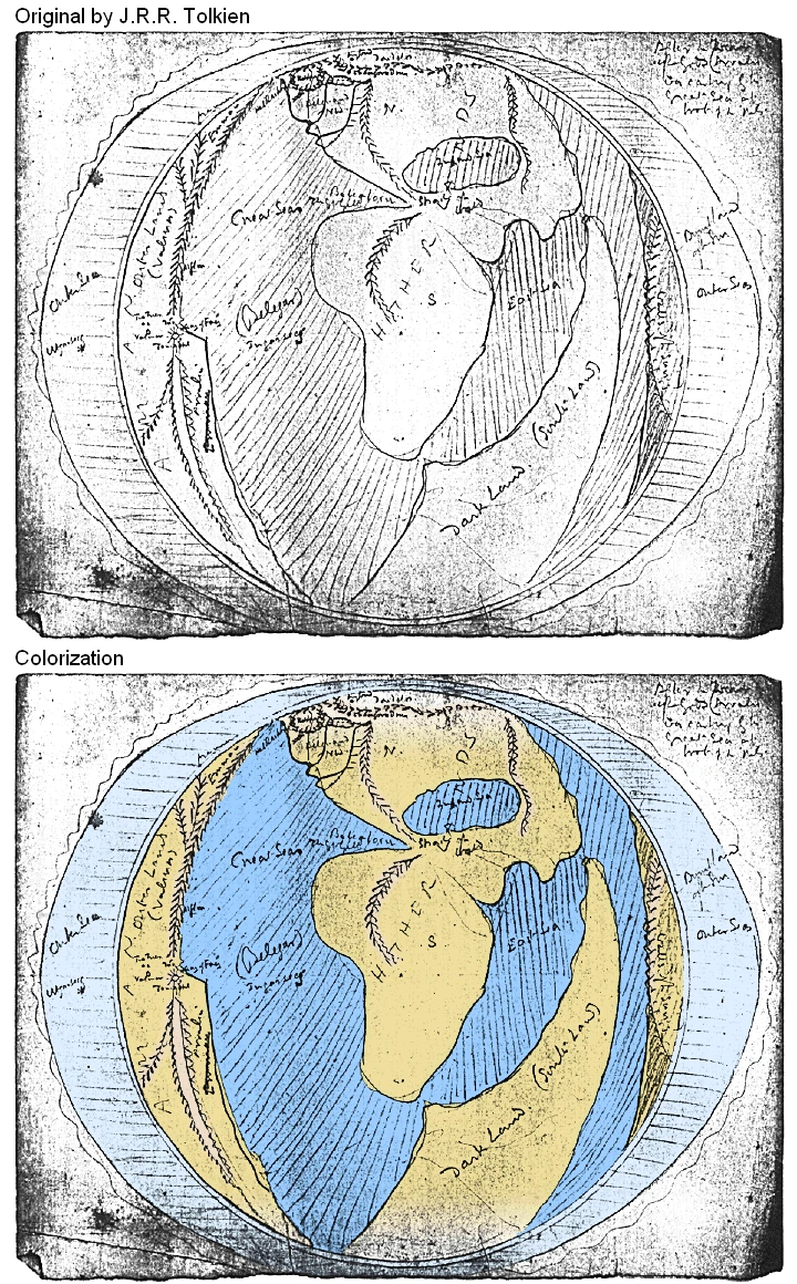
Tolkien's original map of the Dark Land in relation to the rest of Arda during the First Age
- See also Mordor, the dwelling place of Sauron which bears a name that means "Dark Land"
The Dark Land, also referred to as the South Land, was a continent that lay southeast of where the events of the The Silmarillion and The Lord of the Rings occurred.
History
The Dark Land was created as a byproduct of the War for Sake of the Elves, in which the Valar overthrew Melkor in his original fortress of Utumno.[1] Originally, Middle-earth was one landmass, set between the western sea of Belegaer and the East Sea.[2] This changed during the War, when the inland Sea of Ringol, originally landlocked and set in the mid-south of Middle-earth, grew in size and "became a great sea flowing north-eastward and joining by straits both the Western and Eastern Seas."[3] This event split Middle-earth into two landmasses; the landmass to the south and east of the former Sea of Ringil (which was also called the "East Sea" by Tolkien) was known as the Dark Land.[4]
No habitations in the Dark Land were ever recorded. The Númenóreans might have visited it on their long eastward journeys. If so, it is not known whether they established dwellings there.
Portrayal in adaptations
In The Atlas of Middle-earth, Karen Wynn Fonstad interprets the continent as being covered by vast dense forests bordering much of its shorelines.[5][6]
In the game Middle Earth Role Play by Iron Crown Enterprises, a Quenya name for the Dark Land, Mórenorë ("Dark Land"), was given, although it does not appear in any of Tolkien's writings; the name Hyarmenor, "south-land" is given instead in Tolkien's works (as seen in The History of Middle-earth).
Behind the scenes
Before Africa was visited by people from Europe, it was known as the "Dark Land". It is possible that Tolkien was inspired by this; also, he was born in South Africa. However, the continent directly south of Gondor where Harad was located (possibly corresponding with the Sahara Desert, as they are similar in position) is closer in shape to Africa, as well as being the proper distance away from northwest Middle-earth (if northwest Middle-earth is taken to be Europe and Rhûn is taken to be Asia).
As seen in the Ambarkanta, Dark Land occupies a position in Arda much like Antarctica and Australia do compared to Eurasia, if Antarctica and Australia were one landmass.
Some fans have speculated that this land may have become the southern portion of the New Lands at the end of the Second Age (the Land of the Sun being the northern portion).
Translations
| Foreign Language | Translated name |
| Afrikaans | Donker land |
| Albanian | Vendi i errët |
| Amharic | ጥቁር አገር |
| Arabic | بلد مظلم |
| Azerbaijani | Qaranlıq diyar |
| Basque | Herrialde iluna |
| Belarusian Cyrillic | Цёмная краіна |
| Bengali | অন্ধকার দেশ |
| Bosnian | Mračna zemlja |
| Bulgarian Cyrillic | Тъмна страна |
| Cambodian | ប្រទេសងងឹត |
| Catalan | País fosc |
| Cebuano | Ngitngit nga nasud |
| Chinese | 黑暗大陸 |
| Croatian | Tamna zemlja |
| Czech | Tmavá země |
| Danish | Mørkt Land |
| Dutch | Donker land |
| Estonian | Tume riik |
| Faroese | Myrkt land |
| Filipino | Madilim na bansa |
| Finnish | Musta maa |
| French | Terres sombre |
| Galician | País escuro |
| Georgian | ბნელი ქვეყანა |
| German | Dunkelland |
| Greek | Σκοτεινή χώρα |
| Gujarati | ઘેરો દેશ |
| Hebrew | ארץ כהה |
| Hindi | अंधेरा देश |
| Hungarian | Sötét ország |
| Icelandic | Myrkur land |
| Indonesian | Negara gelap |
| Italian | Terra Oscura |
| Japanese | 暗い国 |
| Kannada | ಡಾರ್ಕ್ ಕಂಟ್ರಿ |
| Kazakh | Қараңғы ел (Cyrillic) Qarañğı el (Latin) |
| Korean | 어두운 나라 |
| Kyrgyz Cyrillic | Караңгы өлкө |
| Laotian | ປະເທດຊ້ໍາ |
| Latvian | Tumša valsts |
| Lithuanian | Tamsiai šalis |
| Macedonian Cyrillic | Темна земја |
| Malagasy | Firenena maizina |
| Malayalam | ഇരുണ്ട രാജ്യം |
| Maltese | Pajjiż skur |
| Marathi | गडद देश |
| Mongolian Cyrillic | Харанхуй улс |
| Nepalese | गाढा देश |
| Norwegian | Mørkt land |
| Pashto | تور هیواد |
| Persian | کشور تاریک |
| Polish | Ciemny Ląd |
| Portuguese | País escuro |
| Punjabi | ਹਨ੍ਹੇਰਾ ਦੇਸ਼ |
| Romanian | Țara întunericului |
| Russian | Тёмные Земли |
| Scottish Gaelic | Dùthaich dhorcha |
| Sindhi | ڪارو ملڪ |
| Sinhalese | අඳුරු රට |
| Slovak | Temná krajina |
| Slovenian | Temna dežela |
| Spanish | País oscuro |
| Swahili | Nchi ya giza |
| Swedish | Mörkt land |
| Tajik Cyrillic | кишвари торик |
| Tamil | இருண்ட நாடு |
| Telugu | చీకటి దేశం |
| Thai | ประเทศที่มืด |
| Turkish | Karanlık Diyar |
| Turkmen | Garanky ülke |
| Ukrainian Cyrillic | Темна країна |
| Urdu | سیاہ ملک |
| Uzbek | Қоронғу мамлакат (Cyrillic) Qorong'u mamlakat (Latin) |
| Vietnamese | Đất nước đen tối |
| Welsh | Gwlad Dywyll |
| Yiddish | טונקל לאַנד |
| Yoruba | Orilẹ-ede dudu |
|
Places of Middle-earth and Arda
Middle-earth Locations:
Provinces/Regions: Arnor | Dunland | Ettenmoors | Forochel | Forodwaith | Gondor | Harad | Ithilien | Khand | Lindon | Minhiriath | Mordor | Rhovanion | Rhûn | Rivendell | Rohan | The Shire Forests & Mountains: Amon Dîn | Amon Hen | Amon Lhaw | Caradhras | Emyn Muil | Erebor | Fangorn Forest | High Pass | Iron Hills | Lórien | Mirkwood | Mount Doom | Mount Gundabad | Old Forest | Orod-na-Thôn | Tower Hills | Weathertop Hill City/Fortifications: Angband | Barad-dûr | Bree | Caras Galadhon | Dol Guldur | Fornost Erain | Hornburg | Isengard | Minas Morgul | Minas Tirith | Last Homely House | Tower of Amon Sûl | Tower of Orthanc | Osgiliath | Umbar | Utumno Miscellaneous: Argonath | Astulat | Buckland | Cair Andros | Dagorlad | Dead Marshes | Enedwaith | Fords of Isen | Gap of Rohan | Grey Havens The rest of Arda:
Aman | Burnt Land of the Sun | Dark Land | Empty Lands | Neldoreth | New lands | Númenor | Tol Eressëa |
References
- ↑ The History of Middle-earth, Vol. IV: The Shaping of Middle-earth, V: "The Ambarkanta", First Ballantine Books Edition
- ↑ The History of Middle-earth, Vol. IV: The Shaping of Middle-earth, chapter V: "The Ambarkanta", Map IV
- ↑ The History of Middle-earth, Vol. IV: The Shaping of Middle-earth, chapter V: "The Ambarkanta", First Ballantine Books Edition
- ↑ The History of Middle-earth, Vol. IV: The Shaping of Middle-earth, chapter V: "The Ambarkanta", First Ballantine Books Edition, Map V
- ↑ The Atlas of Middle-earth, The First Age, The Elder Days, "Introduction"
- ↑ The Atlas of Middle-earth, The Second Age, "Introduction"